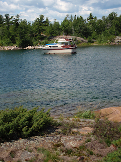


The entrance to Fox Harbour itself is hidden and requires lining up small rock outcroppings by Eagle Island and then winding through some shoals and small islets.
It has a fairly long, narrow opening and most of the boats anchor and tie their sterns to shore. It is easier to do this on the EAST side of the harbor as the trees on the WEST side have scrub, brush, and thicket that block a clear path. We know this because we tried to do the "tie to shore" thing on the WEST side.
It seems like a fairly simple thing. Drop your anchor, tie a line to your stern cleat, dinghy to shore, tie to a tree or a boulder. It's a little harder than it looks. Especially when it is windy ... and your boat weighs 14 tons.
Phil readied the lines, including a few extra in case it was farther to shore than it looked.
He dinghyed in and discovered the scrub and thicket obscuring the trees. So much for Plan A. So he tried Plan B: Tie to a boulder.
But the line slipped off. So he went to Plan C.
After about an hour, he got hungry and tired so we went to Plan D which was coming back to Meridian and setting a second anchor in the Y formation.
As it turned out, it was good that we hadn't tied to shore. Our sailboat neighbor had been tied to shore but when the wind shifted, his anchor gave so he undid the shore line and re-anchored further west and in the middle of the channel. At least that's what he SAID happened. He may not have felt safe anchoring near a boat who's crew couldn't even manage a line-to-shore anchor technique. Come to think of it, he may have been part of the Meridian Spotters Club that we interrupted on Croker Island. We think we heard him on the radio saying "No, seriously, they are right here in Fox Harbour -- I'm looking right at them!"
Fox Harbour is protected from all winds, but less so if there are southwest winds. So, of course, the winds started coming from the southwest right after we got there. 
As we left the next morning, we saw the sailboat SOLUTIONS tucked away in one of the snug little coves off the main Fox Harbour channel.
Sunday, July 27, 2008
Fox Harbour, North Channel
Posted by
Great Lakes Cruising
at
7:53 PM
![]()
![]()
Subscribe to:
Post Comments (Atom)


No comments:
Post a Comment